Mindoro is the seventh largest and eighth-most populous island in the Philippines. It is located off the southwestern coast of Luzon and northeast of Palawan. Mindoro is divided into two provinces: Occidental Mindoro and Oriental Mindoro. In past times, it has been called Ma-i or Mait by Han Chinese traders. Indigenous groups are called Mangyans. The name Mindoro was likely a corruption of the native name “Minolo”. The Spaniards called the place as Mina de Oro (meaning “gold mine”) from where the island got its current name.
Spending my weekends on a new province has been my hobby since my visita iglesia days, so I took this chance to visit two provinces within an islanf, as part of my #project81.
Mimaropa (usually capitalized in official government documents), formerly known as the Southwestern Tagalog Region, is an administrative region in the Philippines. It was also formerly designated as Region IV-B until 2016. It is one of two regions in the country having no land border with another region (the other being Eastern Visayas). The name is an acronym combination of its constituent provinces: Mindoro (divided into Occidental Mindoro and Oriental Mindoro), Marinduque, Romblon and Palawan. Calapan is Mimaropa’s regional center.
I have visited the island provinces of Palawan and Marinduque before so this will be my first time to visit Mindoro provinces extensively, not just the Municipality of Puerto Galera where the famous white Beach is located. Hence, my itinerary became Mindoro Clockwise Town-hopping Solo Trip! Presenting my itinerary below with Calapan City Port as entry and Abra de Ilog Port as my exit point:
My Mindoro Clockwise Town-hopping Travel Map doing east-west and north-south route from Calapan City in Oriental Mindoro up to Abra de Ilog in Occidental Mindoro.
HIGHLIGHTS PER PROVINCE:
ORIENTAL MINDORO Calapan City 📍Oriental Mindoro Provincial Capitol 📍Calapan City Hall 📍Calapan City Plaza 📍Santo Niño Cathedral 📍Oriental Mindoro Heritage Museum 📍Kalap Civic Park 📍Mangyan Heritage Center, Inc. for Mangyan-made local products 📍Old Calapan City Hall 📍Merl’s Native Delicacies for their famous Suman sa lihiya and other pasalubong Pinamalayan 📍Pinamalayan Rainbow Pot 📍Pinamalayan Municipal Hall 📍Pinamalayan Park 📍St. Augustine Parish Church 📍John-Nette Banana Chips for Pinamalayan’s favorite pasalubong Roxas 📍Roxas Municipal Hall 📍Sto. Nino Parish Church 📍Capitol in the South
OCCIDENTAL MINDORO San Jose 📍San Jose Municipal Hall 📍San Jose Rotonda Landmark 📍St. Joseph the Worker Cathedral 📍San Jose Municipal Plaza 📍RICHBLITZ Sweets Pasalubong Center for local products 📍Solid Food Station for their delicious halo-halo Mamburao 📍Occidental Mindoro Provincial Capitol 📍Mamburao Municipal Hall 📍Nuestra Señora del Pilar Parish 📍Provincial Capitol Compound
The Port of Calapan (Filipino: Pantalan ng Calapan) or the Calapan Baseport is a seaport in Calapan, Oriental Mindoro in the Philippines. It is the main port serving Oriental Mindoro. The port has at least seven berths which can accommodate fastcraft, conventional and RoRo vessels. Primary items handled at the port are agricultural products such as copra, rice, and bananas for outgoing cargo and cement, fertilizer and general commodities for incoming cargo. Its passenger terminal can accommodate 800 people at a time, and is being expanded to accommodate 3,500 passengers. Upon completion, the Port of Calapan will have the biggest seaport terminal in the Philippines by passenger capacity.
MANGYAN PAKUDOS MASK A pakudos is a visual motif used by the Hanunuo Mangyan people of Mindoro in the Philippines. Pakudos is characterized by symmetrical, aesthetic, and orderly utilization of lines and space with equal utilization of vertical and horizontal composition. The word pakudos was coined from cruz, the Spanish word for cross. The pakudos motif is a common element in Mangyan embroidery and crafts. It is also seen on the official seal of San Jose, Occidental Mindoro. It is said that the Pakudos is a variation of the Indic swastika. In addition to the basketry, the Pakudos is also used to embellish traditional Mangyan shirts. A man’s shirt – the balukas – and a woman’s blouse – the lambung – are embroidered in intricate and extensive pakudos, predominantly in red, white and black. Pakudos is the traditional symbol to ward off evil spirits and now serves as motif in their handicrafts and apparel.
The tamaraw or Mindoro dwarf buffalo (Bubalus mindorensis) is a small hoofed mammal belonging to the family Bovidae. It is endemic to the island of Mindoro in the Philippines, and is the only endemic Philippine bovine. It is believed, however, to have once also thrived on the larger island of Luzon. The tamaraw was originally found all over Mindoro, from sea level up to the mountains (2000 m above sea level), but because of human habitation, hunting, and logging, it is now restricted to only a few remote grassy plains and is now a critically endangered species. Contrary to common belief and past classification, the tamaraw is not a subspecies of the water buffalo, nor is it a subspecies of the slightly larger carabao, which is classified as a subspecies of the water buffalo. In contrast to the carabao, the tamaraw has a number of distinguishing characteristics; it is slightly hairier, has light markings on its face, is not gregarious, and has shorter horns that are somewhat V-shaped. It is the second-largest native terrestrial mammal in the country next only to the carabao.
Oriental Mindoro (Tagalog: Silangang Mindoro), is a province in the Philippines located on the island of Mindoro under Mimaropa region in Luzon, about 140 kilometres (87 mi) southwest of Manila. The province is bordered by the Verde Island Passage and the rest of Batangas to the north, by Marinduque, Maestre de Campo (or known as Sibale but official name is Concepcion) Island, Tablas Strait and the rest of Romblon to the east, by Semirara and the rest of Caluya Islands, Antique to the south, and by Occidental Mindoro to the west. Calapan, the only city in the island, is the provincial capital, province’s largest LGU and Mimaropa’s regional center. My 71st province! (n_n)
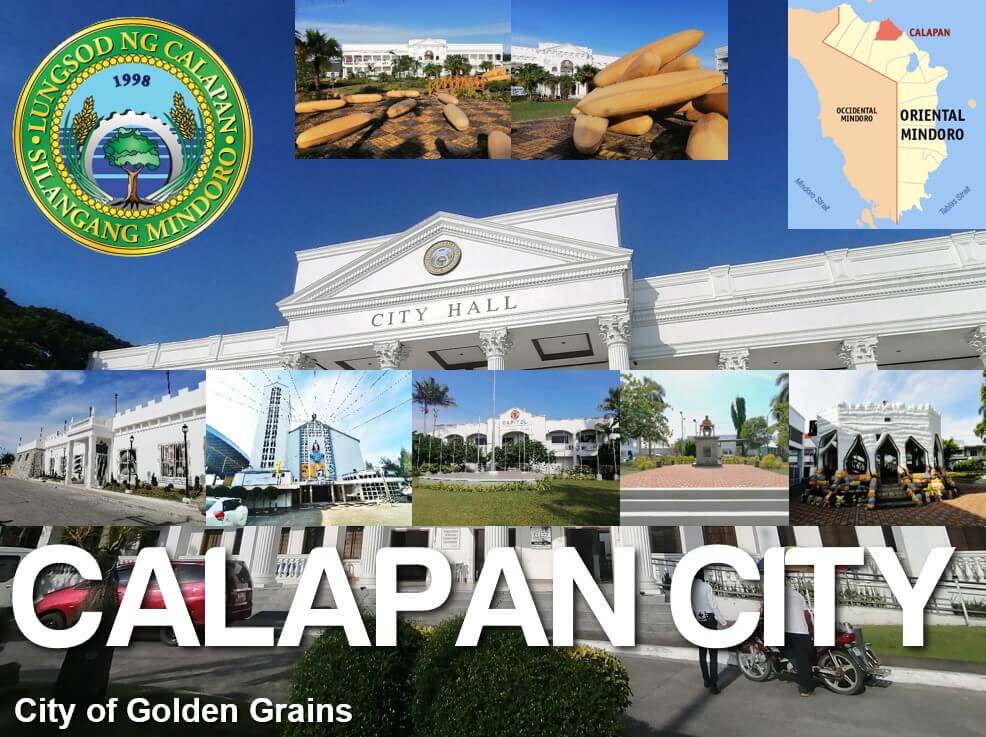
Calapan, officially known as the City of Calapan (Tagalog: Lungsod ng Calapan), is a 3rd class component city and capital of the province of Oriental Mindoro, Philippines. According to the 2020 census, it has a population of 145,786 people. The city serves as the gateway to the Oriental Mindoro province with the implementation of the Strong Republic Nautical Highway (SRNH) an integrated ferry project of then President Gloria Macapagal Arroyo that extends further to the southern part of the Philippines. The Calapan City Seaport is the largest and busiest seaport on Mindoro Island, which is just 45 minutes away by ferry boats and roll-on/roll-off (RORO) ships to-and-from Batangas City International Seaport. Calapan is one of two cities in the Mimaropa region, the other being Puerto Princesa in Palawan. Calapan serves as the region’s administrative center. It is also the center of commerce, industry, transport, communication, religious activities and education in the entire province of Oriental Mindoro.
The derivation of the name of Calapan cannot be traced with certainty. Some opined that it came from the word “Kalap” which means to gather logs. Thus “Kalapan” was supposed to be a place where logs were gathered. In the old records, however, there was never a mention of Calapan as a place where logs were produced or exported. Furthermore, huge forest trees where logs were produced certainly did not grow near the town, which was swampy. Another theory holds that Calapan was originally pronounced as “Kalapang” which, according to an old Tagalog dictionary, was a synonym for “sanga” or branch. It could then refer to the settlement of Kalapang as a branch of its mother town of Baco, an adjoining town. The name was later hispanized as Calapan.
The Diocese of Calapan (Latin: Dioecesis Calapanensis) is a Latin Church diocese of the Catholic Church in Oriental Mindoro, Philippines. It has six related parishes. The episcopal residence and seat of the diocese is the Santo Niño Cathedral located in Calapan.
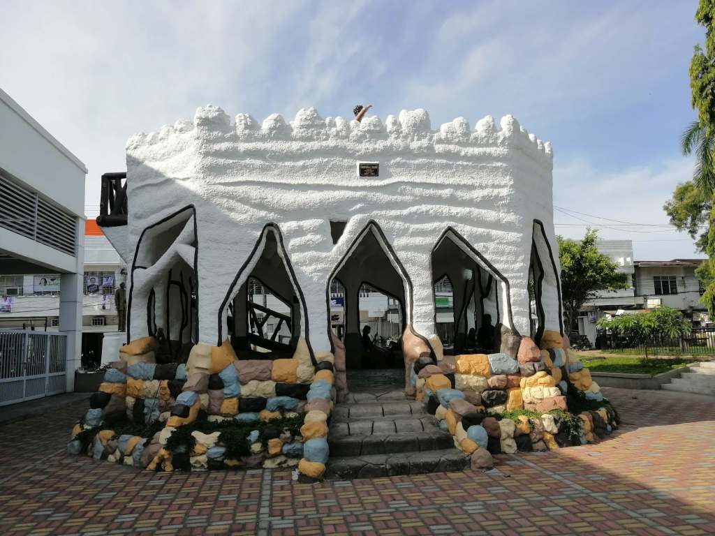
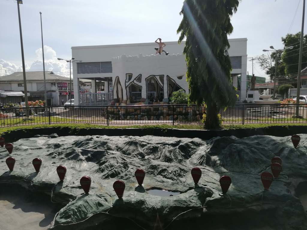
The Oriental Mindoro Heritage Museum (OMHM) was built at the Old Provincial Capitol of Oriental Mindoro in Brgy. Ibaba East, Calapan City where the Cal-kuta, an abandoned Spanish fortress stands. With a combination of classic and modern designs, its features are inspired by the “MAHAL TANA” theme which highlights the iconic symbols of Oriental Mindoro – Mangyan, Halcon, Tamaraw and Naujan Lake. *Prior booking here is advised to enter the museum halls
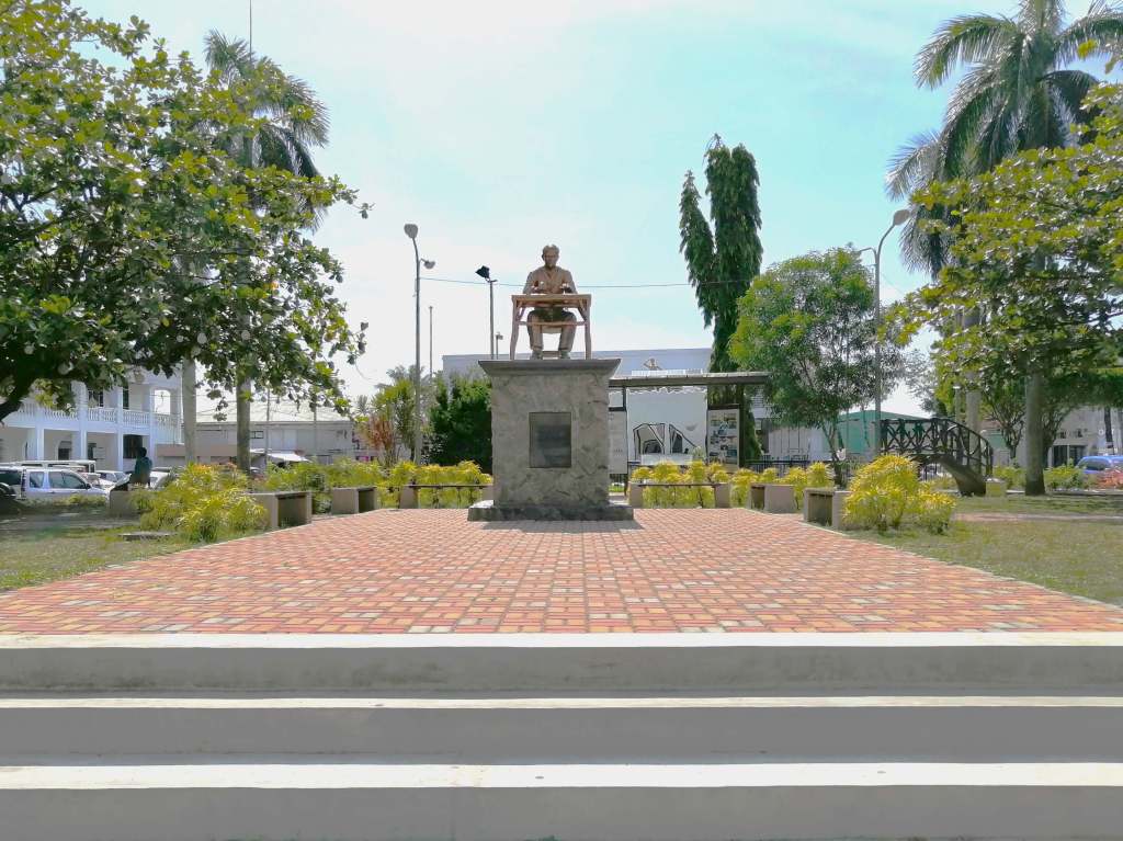
Mangyan Heritage CenterThe GazeboThe Old Calapan City HallCalapan City Plaza “The plaza serves as a rotonda, in the middle of which lies a cemented gazebo. The gazebo is wrapped with a spiralling staircase, leading to its rooftop. At the rooftop you’ll find statue of a Mangyan next to a Tamaraw, a dwarf buffalo endemic to Mindoro. The Mangyans are the indigenous people of Mindoro Island. Also found in this plaza are a relief sculpture of Mindoro and a monument of Dr. Jose Rizal, the National Hero.”Lunch at Five in One near Calapan City Plaza
Pinamalayan, officially the Municipality of Pinamalayan (Tagalog: Bayan ng Pinamalayan), is a 1st class municipality in the province of Oriental Mindoro, Philippines. Pinamalayan is 70 kilometres (43 mi) from Calapan. The town of Pinamalayan is one of the oldest in the province of Oriental Mindoro. Its territory once went as far as the old settlements of Sumagui and Anilao which are now part of the towns Bansud and Bongabong respectively. The Town of Pinamalayan was also a former part of Pola until it got its permanent township status in the early years of American Colonization while Gloria was separated from Pinamalayan in 1964.
The town of Pinamalayan is close to the shore at the mouth of the river of the same name. The town’s name was said to be taken from the word “Ipinamalay na” which means to make aware or to show the way or it has been made known to us. According to an old story, the early settlers of this town came from Marinduque. While they were on their way to Mindoro in their big bancas (boats), they encountered turbulent weather and lost their way. They prayed to the God Almighty for deliverance and guidance, whereupon, the weather cleared and a rainbow appeared on the horizon, and guided them towards safety and to a place where they discovered abundant resources and endless promises. The crew shouted “ipinamalay na” (it was made known). They followed the direction of the rainbow believing that at its en lies a pot of gold and good fortune. They finally landed at what is now Barangay Lumambayan and established the first settlement which they named Pinamalayan. They found good fortune in the new land which brought them prosperity because of the good soil and abundant resources.
Roxas, officially the Municipality of Roxas, is a 2nd class municipality in the province of Oriental Mindoro, Philippines. Founded by Andres Torrefiel on November 15, 1948, it was formerly known as Paclasan, originally a part of Bulalacao, Oriental Mindoro, then a barrio of Mansalay, Oriental Mindoro.It was named after President Manuel A. Roxas, the first town to be named as such. Located 126 kilometres (78 mi) from the main capital city of Calapan, Roxas is the smallest municipality of Oriental Mindoro. In 2003, the Strong Republic Nautical Highway (SNRH) was inaugurated, resulting in the opening of the Port of Roxas, located in Barangay Dangay. The town then became a transit point to Boracay, Romblon (Odiongan and Sibuyan), and Palawan. Several shipping companies such as Starlite and Montenegro Shipping Lines serve this route.
Occidental Mindoro (Tagalog: Kanlurang Mindoro) is a province in the Philippines located in the Mimaropa region. The province occupies the western half of the island of Mindoro. Its capital is Mamburao, but the largest municipality is San Jose. As of 2020, Occidental Mindoro has 525,354 inhabitants. The province is bordered on the east by the province of Oriental Mindoro, and on the south by the Mindoro Strait. The South China Sea is to the west of the province and Palawan is located to the southwest, across the Mindoro Strait. Batangas is to the north, separated by the Verde Island Passage, a protected marine area and the center of the center of the world’s marine biodiversity. My 72nd province! (n_n)
San Jose, officially the Municipality of San Jose (Tagalog: Bayan ng San Jose), is a 1st class municipality in the province of Occidental Mindoro, Philippines. It has a population representing a third of the provincial population, and is the largest among cities (excluding Puerto Princesa City) and municipalities in the Mimaropa region. San Jose has the province’s largest commercial port and airport, the most banking, business, dining and commercial establishments in Occidental Mindoro, and has become a center of trade in the Mimaropa region. Its major local and international exports include rice, salt and processed milkfish. In pre-colonial times, it was named Pandurucan by the indigenous Mangyans after the local river, before later renamed for its patron saint, St. Joseph, the husband of Mary.
The Apostolic Vicariate of San Jose in Mindoro is a Latin Church missionary jurisdiction or apostolic vicariate of the Catholic Church in the western part of Mindoro island in the Philippines. It comprises the civil province of Occidental Mindoro and its 11 municipalities. Its cathedra is within the Cathedral of St. Joseph the Worker, in the episcopal see of San Jose.
Dinner at Solid Food Station in San Jose, OccMin
Mamburao officially the Municipality of Mamburao (Tagalog: Bayan ng Mamburao), is a 2nd class municipality and capital of the province of Occidental Mindoro, Philippines. The Municipality of Mamburao lies on the level area of the coastal bank of Mamburao River and extends far beyond into interior at the foot of the mountains.
The town is situated along Mamburao Bay, between Tubili Point and Mamburao Reef, and affords good anchorage. Mamburao River empties into the bay about 3¼ miles eastward of Tubili Point. The bay has a good anchorage for northerly and easterly winds, but it’s exposed to the southeast monsoon. The Mamburao Reef extends 3¼ miles southward from Caroisan Point.
The Port of Abra de Ilog (Filipino: Pantalan ng Abra de Ilog) is a seaport in Abra de Ilog, Occidental Mindoro in the Philippines. It is the main seaport of northern Occidental Mindoro. Household consumption goods are the main cargoes imported in the port while outgoing cargoes are agricultural products such as corn, rice, and livestock.


1 thought on “Mindoro: The Clockwise Town-hopping Tour”